
Water Warnings
Air Date: Week of December 2, 2005
A group of engineering students from MIT have come up with a cheap, yet effective, flood warning system. Host Steve Curwood talks with Elizabeth Basha of the Flood Safe Early Warning project about the group’s work in hurricane ravaged Honduras.
Transcript
CURWOOD: As this record setting hurricane season demonstrated, high winds can be destructive, but it is massive flooding that often proves to be the most deadly. So warning people that waters are rising has become an acute priority. Nowhere is this need for this more acute than in Honduras, where thousands of people perished in flooding caused by Hurricane Mitch back in 1998. The Honduran government has begun installing a flood warning system but a group of MIT engineering students who’ve been volunteering in the region says it uses expensive technology that’s prone to human error. So they’ve come up with something cheaper and simpler. Elizabeth Basha is a graduate student of electrical engineering and computer science and head of the MIT Flood Safe Early Warning project team.
Elizabeth, before I ask you about your project, can you tell me about the community you’re working in?
BASHA: So we’re working in the northeastern area of Honduras. It’s a river called the Aguan. And we’re working with communities that live on the very end of this river, right where the river meets the Caribbean Ocean, actually. And these communities are in a very precarious position. The river is very flat, and so the area they live on, when it does flood, the water just spreads out and engulfs them.
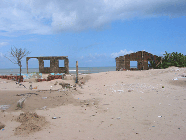
A view of Santa Rosa de Aguan, a community destroyed by Hurricane Mitch and unable to rebuild. (Photo courtesy of Elizabeth Basha.)
CURWOOD: So what’s wrong with the current flood warning system there? I understand the government of Honduras has installed a pretty sophisticated system, right?
BASHA: It’s not actually that sophisticated. They just installed the system in this river last year, and the way that system works is primarily volunteer-based, in terms of the measurement technique. So, families will have a radio in their home and periodically throughout the day they will go and look at markings on a bridge that tell them the river level; radio that in to a central spot; and that central office, run by the government, collects all this data and then determines what the alert system should be. And they do sometimes take into account some satellite sensors that were installed by the USGS but, primarily, it’s based on these markings on the river.
CURWOOD: So what’s wrong with that?
BASHA: The problem is those people don’t necessarily go out in the middle of the night.
CURWOOD: Ooh.
BASHA: And Mitch caused a wall of water in the middle of the night. So…
CURWOOD: So they were sleeping. And I suppose it’s not a problem for them. If they’re upstream and there’s a lot of water, it’s interesting, but if you’re downstream, it’s a disaster.
BASHA: Exactly, and that’s the key problem in this basin. And they’ve successfully installed the system in very small basins, where the same people measuring are the same people affected. But, in this instance, the people upstream aren’t affected by the flooding in the same way.
CURWOOD: Tell me about the system that your group at MIT has developed. Where’s it located? How does it work?
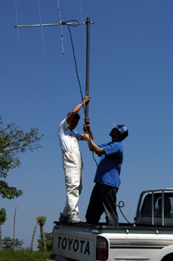
A MIT student works with an employee of the Centro Tecnico San Alonso Rodriguez to hold a radio antenna for communication testing purposes. (Photo courtesy of Elizabeth Basha.)
CURWOOD: So, you’ve designed a system that’s, well, it’s rather complex, but at the same time, well, it’s fairly simple. So this is an example of simple being better?
BASHA: I think in this situation we examined the problem and tried to solve it in a very different way than the people had done before. I mean, the USGS had installed these satellite sensors with the same idea, but it seems that they haven’t considered the problems that those sorts of things have. Satellite systems are very expensive, there’s long term messaging costs, and those sorts of issues. And instead, we went down and we said, okay, we know we don’t have a lot of money, and we know that we need to install something that’s easy to maintain, and we went as low-tech and as minimalistic as possible in order to do that. And I think that our end result is a system that’s much easier to install, much easier to maintain, and really solves the problem.
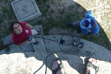
Elizabeth Basha looks up from the base of a water tank during radio communication testing in Honduras. (Photo courtesy of Elizabeth Basha.)
CURWOOD: Elizabeth Basha is an MIT graduate student of electrical engineering and computer science, and back to Honduras sometime in the near future. Thanks for stopping by.
BASHA: Thank you.
Links
Living on Earth wants to hear from you!
Living on Earth
62 Calef Highway, Suite 212
Lee, NH 03861
Telephone: 617-287-4121
E-mail: comments@loe.org
Newsletter [Click here]
Donate to Living on Earth!
Living on Earth is an independent media program and relies entirely on contributions from listeners and institutions supporting public service. Please donate now to preserve an independent environmental voice.
NewsletterLiving on Earth offers a weekly delivery of the show's rundown to your mailbox. Sign up for our newsletter today!
![]() Sailors For The Sea: Be the change you want to sea.
Sailors For The Sea: Be the change you want to sea.
 The Grantham Foundation for the Protection of the Environment: Committed to protecting and improving the health of the global environment.
 Contribute to Living on Earth and receive, as our gift to you, an archival print of one of Mark Seth Lender's extraordinary wildlife photographs. Follow the link to see Mark's current collection of photographs.
 Buy a signed copy of Mark Seth Lender's book Smeagull the Seagull & support Living on Earth
© Copyright World Media Foundation. All Rights Reserved
Home | Contact | RSS | Donate | Newsletter