
Defending the Gulf Coast
Air Date: Week of January 27, 2017
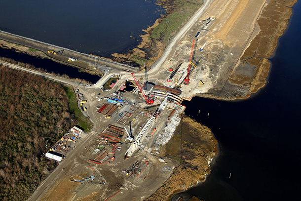
U.S. Army Corps of Engineers crews installed a floodwall around a drainage pump station in New Orleans East in 2011. (Photo: U.S. Army Corps of Engineers, Flickr CC BY 2.0)
The Louisiana coast is losing ground in the battle against rising seas. So the state has been working on a master plan to shore up the coast and protect homes with wetlands restoration and higher levees. New Orleans Times-Picayune environment reporter Mark Schleifstein filled in host Helen Palmer about the projects in the updated $50 billion, 50 year plan, and the public response.
Transcript
PALMER: It’s Living on Earth. I’m Helen Palmer, in for Steve Curwood.
The disaster of Hurricane Katrina in 2005 made clear quite how vulnerable New Orleans and the low lying communities along the Gulf Coast are to fierce storms and surging seas. So a master plan was devised to shore up defenses and repair the sinking coastline that protects the city. Now authorities have released an updated $50 billion, 50-year plan that rethinks and bolsters those defenses even more.
Mark Schleifstein, an environment reporter with the New Orleans-based Times-Picayune, has been reporting on the plan and following the public’s response. Mark, welcome back to Living on Earth.
SCHLEIFSTEIN: Well, thank you. I appreciate the opportunity.
PALMER: Now, tell me a little about this new $50 billion plan. What does it propose to do?
SCHLEIFSTEIN: Well, it's actually an update of an existing plan that is in place to provide both restoration for coastal wetlands along the coast of Louisiana, but also with an intent of making sure those restoration projects are combined with projects to improve levees and other structural ideas to reduce risk from hurricane storm surges. And the plan is literally divided in half, $25 billion goes to restoration projects, and $25 billion is going into what you would call protection projects, levees. But also a significant chunk of that money is going into helping people raise homes above hundred-year floodplains and also to, in some cases, to move them out of the floodplains.
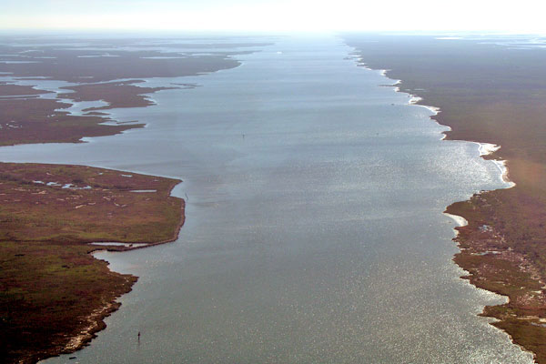
The now-defunct Mississippi River Gulf Outlet, or MRGO (Photo: Jim Flocks / USGS, CC government work)
PALMER: Now, there was a plan before. How does this change the plan before and why did the plan before need changing?
SCHLEIFSTEIN: Well, the reality is that the state has the financial resources, heck of a lot of money from the BP oil spill, to begin construction of some of these projects, and it has a lot more of the science necessary to help design some of these projects, and more information about how high especially sea level will be, which has required them to make dramatic changes in what they would expect to happen.
PALMER: So, basically they've had to update it and make it tougher and make it able to build higher levees and raise houses higher?
SCHLEIFSTEIN: Well, it's more question of what can they save and what they can't, and they've made very clear while they keep talking about $50 billion in 50 years, there's a recognition that the $50 billion is just a start for what will be a continuous, long-term process of providing more protection and more restoration. And the other key piece of that is that there's a clear understanding and recognition by the state written into the report that, unlike the last five-year update, this time they're not saying that we're going to get to a no-net-loss of wetlands situation, that even with this plan in place there will be a significant loss of wetlands along the state's coast. And, indeed, they talk about for their mid-level projection of sea level rise, that the projects that they want to build over 50 years, at the end of those 50 years, they would create 802 square miles, but the reality is that the state would also still lose 2,000 square miles. That's an area the size of Delaware.
PALMER: Wow. And they're actually planning to rebuild some of the wetlands? How are they doing that?
SCHLEIFSTEIN: OK. So, there's two key ways that they’re going to be doing that. One is rather direct. Basically they are going to be mining sediment out of the Mississippi River. There is still enough sediment that the river carries each year that it is building bars and sand deposits within the navigation channel and on the sides of the navigation channel. So, they actually dredge that material out, and they pump it inland through pipelines, and they have pipelines as long as 20 miles already that they’ve been pumping this stuff through to start building wetlands. I mean, literally building wetlands and land across the surface in areas that have turned into open water over the last 80 years.
The other thing that they're doing is, they're attempting to build several sediment diversions, large structures that will be put in the levee system that will capture a portion of the flow of the Mississippi River with its sediment load when there are high river periods and use that material to both build land over a longer period of time and also to have that material added to the wetlands they've already built into the wetlands that exist, to help it keep up with the rising sea level.
PALMER: So, the sediment diversions actually work, do they? They actually manage to build wetlands like that?
SCHLEIFSTEIN: Well, that's a good question, and that's one of the key issues that remains to be seen. You know, these will be the first major sediment diversions of this size, 75,000 cubic feet per second, that will be designed to create wetlands. So, they think, based on their modeling, that it works. They also know based on where they have had diversions for flood purposes - You know, there's the Bonnet Carré Spillway that is just north and west of New Orleans - That spillway is opened up when there's a really high river. That's spillway completely fills with settlement every time they open it up, and it's, you know, 10 miles long, and it's like 30 feet deep.
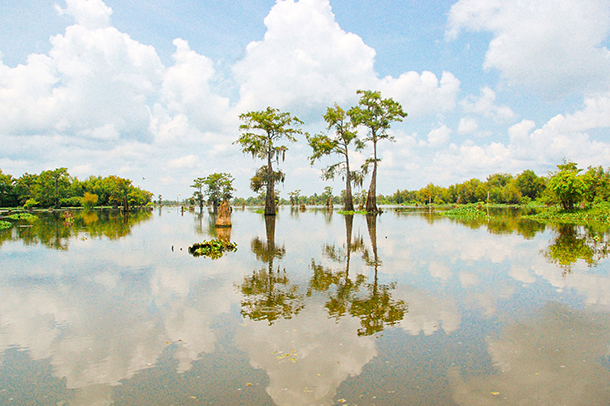
PALMER: I read that they're actually hoping to rebuild a Cypress Tupelo forest next to the Lower Ninth Ward. That sounds really exciting.
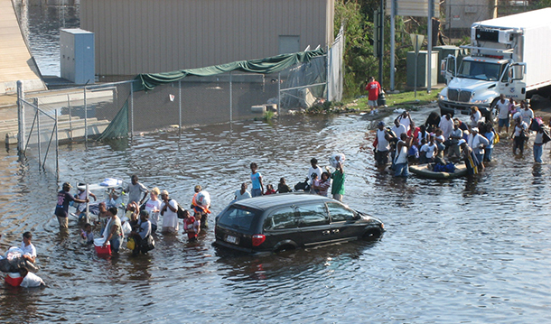
New Orleans residents flee the floodwaters during Hurricane Katrina (Photo: News Muse, Flickr CC BY-NC-ND 2.0)
SCHLEIFSTEIN: That's true. There used to be a shortcut for shipping that went to downtown New Orleans called the Mississippi River Gulf Outlet or the Mr. Go. It was only completed 1965, but since then the Cypress forest that was in that area, what remained of it, has died because of the salt water that it allowed in. After Katrina, it was determined by Congress that that navigation channel needed to be closed because it was no longer financially feasible. It really wasn't even before Katrina. So they dammed it off at a midpoint, and they're going to be filling in part of the area that was a Cypress forest to get it to the depth where they can start growing Cypress trees again.
PALMER: Now, I also read that one part of the plan would actually divert water away from Atchafalaya Basin, and that's the largest wetlands in the country. Why do they want to take water away from the Atchafalaya?
SCHLEIFSTEIN: OK. So, over time, you know, you had the old river control structure above Baton Rouge, and that basically keeps the Mississippi from flowing down the Atchafalaya and creating a Mississippi River in the path of the Atchafalaya. As part of the requirements for that structure, Congress authorized 30 percent of the river's flow to go into the Atchafalaya Basin. Well, since that happened, all the sediment that goes in with that has been filling those wetlands, so it's creating a new delta at the mouth of the Atchafalaya River along the Gulf Coast, but at the same time it's filling those inland wetlands to points where it's problematical. Well, that's a good source of fresh water and some sediment that the state hopes to capture by moving some of that water into the Barataria Bay, where the worst subsidence is occurring now in the state.
PALMER: Now, part of the plan obviously concerns building berms and building bridges and building things to hold some of the water back. Can you talk a little bit about those kinds of constructions that are part of the plan?
SCHLEIFSTEIN: OK. So, the $25 billion that’s set aside for levees and other things to reduce storm surge, some of the key pieces of that include a very long-term, at the end of the 50-year-period, plan to increase the height of the post-Katrina levee system around New Orleans by as much as three feet. The potential there is to improve the storm surge benefits of that system for New Orleans. While the plan sort of talks about it in the context of a 500-year event, the reality is that in 50 years it may very well be that they're going to need that three feet to keep a hundred-year level of protection for the city of New Orleans which would be enough for them to continue to have flood insurance, you know, federal flood insurance, in that area.
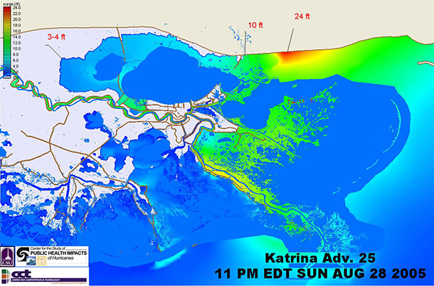
A map showing storm surge during Hurricane Katrina. The areas in red experienced storm surge of 24 feet, and those in bright green experienced 12 feet of surge. (Photo: Matt Ewalt, Flickr CC BY-NC-ND 2.0)
The plan does include a couple of projects that already are in the works. One is something called West Shore Lake Pontchartrain, which is an extension of the New Orleans area levees to the west, and one of the key pieces of that plan is that the Corps of Engineers determined that it would only go through one of the parishes and not two others. And those other two parishes, instead of building a levee through them, they would actually add money to the project to either raise homes above the expected flood plain or to move people out of the floodplain and also to pay, in some cases, for flood-proofing businesses that are in the floodplain.
PALMER: So how, by and large, are the locals responding to this proposed, coastal master plan?
SCHLEIFSTEIN: Well, a number of fisheries groups are not very happy with the diversions. They contend that the additional freshwater will disrupt fisheries. You know, the timing of when shrimp can be caught and where it can be caught, pushing the shrimp out farther away from where the fishermen live and thus forcing them to spend more to catch them. And then with the oysters…You know, Louisiana has long been - or at least until Katrina - had long been a major producer of oysters for the US. There's a clear indication that the additional freshwater from these projects is going to disrupt oyster production.
The other key thing that was raised at a recent hearing was that it may not go far enough to actually deal with the potential effects of sea level rise caused by global warming. The plan itself calls for worst-case scenario looking at 2.72 feet of sea level rise over 50 years, and there have been recent studies out that the amount of sea level rise could be three to four-and-a-half over the next hundred years or even as much as six, when you add in some of the things that are happening with the melting ice caps. So, those issues were raised. The state points out that this is, indeed, a five-year plan and that in five years it will be adopting a new plan, and just like it did this time, it will be upgrading those features.
The Atchafalaya basin is filling in with sediment (Photo: matt northam, Flickr CC BY-NC-ND 2.0)
PALMER: Now, you said that obviously the money that's coming from the BP settlement after the Deepwater Horizon disaster is not going to be the whole $50 billion, and you say that even $50 billion may not be enough?
SCHLEIFSTEIN: Well, the state recognizes that $50 billion is enough to do what this plan calls for, and it's a limited plan, so where is it getting that money? Well, the key thing right now is, it’s trying to front-end load some of these projects using the BP oil spill money. It's got $10-$12 billion it expects to get from that for specific projects, all for restoration. For the other things it's going have to rely in part on money from offshore, from the Gulf of Mexico, that's coming from oil leases. One of the problems the state has, though, is that it still has to to pay its share of the Katrina levees, which is going to be $98 million a year for 30 years beginning at that same time in 2018.
So, where else is it looking? Well, it's actually looking at private industry, and it's looking at trading. The state just passed a law that allows a company that is attempting to get a permit to do work in wetlands, you know, it has to do mitigation. Well, it used to be that you had to do that mitigation right there in a small project that it has to do to show exactly what's going on. The state would now allow them to put money into basically the coastal master plan to build some of these projects instead. It also will be able to use money from fines, and Governor John Bel Edwards has made clear that he is filing lawsuits against oil and gas industries all across the state, parish by parish, to attempt to capture at least part of the damages that their earlier use of canals and other things for development of oil and gas within the state's borders, things that they did wrong, using that money to help pay for some of these projects as well.
Mark Schleifstein is a Pulitzer Prize-winning environment reporter with the Times-Picayune and is co-leading the newspaper’s new Louisiana Coastal Reporting Team. (Photo: NOLA.com | The Times-Picayune)
PALMER: Is this is a project that is likely to create a lot of jobs for Louisianans?
SCHLEIFSTEIN: Yeah, that's another key thing that's going to occur. You know, after Katrina the reality is, the state benefited from the redevelopment of the levee system which cost $15 billion and all of the construction that occurred in rebuilding everything that was destroyed. A lot of that money ended up resulting in taxes for the state. They're already seeing that there's a viable industry that's being created around coastal restoration, both in terms of engineering for the projects, in terms of a demand for new dredges to do some of the work for dredging and building wetlands. The state hopes and expects that it will be able to actually outsource some of those created jobs to other communities around the world that will need the lessons learned from here in Louisiana.
PALMER: Mark Schleifstein is an environment reporter with the Times-Picayune in New Orleans. Mark, thank you very much.
SCHLEIFSTEIN: Thank you. I appreciate the opportunity.
Links
The 2017 Draft Coastal Master Plan
The Times-Picayune: “Storm surge damage falls $8.3 billion a year in Louisiana’s new coastal plan”
USGS fact sheet: “Louisiana Coastal Wetlands: A Resource At Risk”
Weather Underground: Storm surge during Hurricane Katrina
Mark Schleifstein has been called “the man who predicted the flood”
Living on Earth wants to hear from you!
Living on Earth
62 Calef Highway, Suite 212
Lee, NH 03861
Telephone: 617-287-4121
E-mail: comments@loe.org
Newsletter [Click here]
Donate to Living on Earth!
Living on Earth is an independent media program and relies entirely on contributions from listeners and institutions supporting public service. Please donate now to preserve an independent environmental voice.
NewsletterLiving on Earth offers a weekly delivery of the show's rundown to your mailbox. Sign up for our newsletter today!
![]() Sailors For The Sea: Be the change you want to sea.
Sailors For The Sea: Be the change you want to sea.
 The Grantham Foundation for the Protection of the Environment: Committed to protecting and improving the health of the global environment.
 Contribute to Living on Earth and receive, as our gift to you, an archival print of one of Mark Seth Lender's extraordinary wildlife photographs. Follow the link to see Mark's current collection of photographs.
 Buy a signed copy of Mark Seth Lender's book Smeagull the Seagull & support Living on Earth
© Copyright World Media Foundation. All Rights Reserved
Home | Contact | RSS | Donate | Newsletter