
The View Today
Air Date: Week of June 2, 2006

Darin Lee boats through what used to be the marshlands of his childhood, now mostly open water. (Photo: Molly Peterson)
As construction gets underway to repair the levees of New Orleans, much is being learned about what went wrong and what's to be improved for future hurricane protection in the city. Molly Peterson reports.
Transcript
CURWOOD: This is Living on Earth. I’m Steve Curwood, in New Orleans.
[MUSIC: Louis Armstrong “St. James Infirmary” from ‘Satch Blows the Blues’ (Sony –1929)]
CURWOOD: Those Blues, born along the Mississippi and jazzed up in New Orleans more than a century ago, still reflect the mood of this city in June of 2006. A new hurricane season is on, and Gulf Coast residents are still picking up the pieces from the last one.
Katrina surged through man-made channels and over open water last August 28, killing more than 1,300 people when the levees broke in several places - bringing about the largest civil engineering disaster in American history.
Darin Lee boats through what used to be the marshlands of his childhood, now mostly open water. (Photo: Molly Peterson)
Over the years, as the city sprawled out and coastal industry grew, man-made defenses became even more important. This week, we look at how the Gulf Coast has engineered protection against flooding and hurricanes – and we’ll examine ideas for shielding Gulf residents in the years ahead.
We begin with a look at the repairs still underway at the levees and the quest to find out what exactly caused their failures. Molly Peterson has our report.
[DRIVING ON GRAVEL, BOAT SPLOSHING SOUNDS]
PETERSON: Even during storm season, South Louisianans love to fish. Boat trailers pack the lot at Beson’s Launch, and among them this Saturday is Darin Lee. Lee is a coastal scientist for the state, and he points out the signature of last year’s hurricanes.
LEE: They’re called marsh balls in colloquial terms, these little chunks of marsh that have been thrown out into this eroded area, and now they’re beginning to die, barely sticking up out above the water, and that’s what you see from hurricane damage.
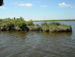
The last remnants of marshland jut out of the water, signaling a rapidly eroding area due to hurricane damage. (Photo: Molly Peterson)
LEE: Everyone understands that friction of this marsh basically reduces that flow of water and buffets that storm surge.
PETERSON: Like these wetlands, the manmade hurricane defenses that protect New Orleans are battered after last year’s storms. The Army Corps of Engineers has been rebuilding the city’s system of levees, dikes and canals, readying for storm season. Engineers and scientists have been trying to understand how mistakes people made are linked to catastrophic flooding – and how to prevent it again.
An Army Corps task force is conducting the official investigation. Co-director Reed Mosher says last year’s storms are teaching investigators more about the system than lab tests ever did.
MOSHER: We’re discovering some things that hadn’t been seen before. Now that’s not good that they’ve led to failures. That’s bad that they have led to failures. But from a science standpoint you do find things when you actually get loadings on them that you have not seen before.
PETERSON: And that new knowledge has made some repairs into improvements. One place the levee system failed early under the strain of the storm was at the Industrial Canal, a wide waterway on the East side of the city. Navigation channels further east funneled storm surge in from the ocean. That sent water over the top of the canal, carving trenches in the ground outside and weakening the walls.
These walls were concrete, surrounded by earthen hills. They tipped over and more water poured into neighborhoods filling streets to the roofs and rain gutters.
[CONSTRUCTION SOUNDS]
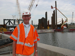
PETERSON: These walls are not coming back. Corp project leader, Chris Gilmore, says they are putting in something wider and stronger, called T-walls.
CHRIS GILMORE: Basically, what a T-wall is is like the letter T, but turned upside down. You have a base at the bottom in front and behind on the flood side, and the protected side, it just provides more support, more of a footprint for the wall itself.
[HOLLOW WIRE TENSION SOUND, DROP CONCRETE]
PETERSON: And along nearly 200 miles of the levee system, crews are adding what’s called scour protection – 8-foot wide beds of concrete – to shield against the force of water if storms surge over the top again.
[HOSE IN CONCRETE]
PETERSON: But it’s an incomplete fix. New concrete and T-walls on the east side of this channel are higher than those on the west. So if a storm surged in here again, the bowl of land on the New Orleans side would get wet first.
[SCRAPING SOUND, TROWEL ALONG SURFACE OF CONCRETE]
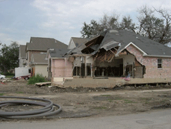
Houses in Lakeview, on the east side of the 17th Street Canal breach, sit wrecked and abandoned. (Photo: Molly Peterson)
Engineers are still working out the complicated story of what happened there. In Vicksburg, Mississippi, Army Corps researchers ran simulations to test how levee walls stood up to the energy of waves coming down the canal.
[SOUND OF WAVE GENERATOR]
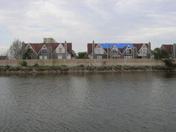
Houses in Orleans Parish sit right on the edge of the 17th Street Canal, as do trees and pools, which make levees less stable. (Photo: Molly Peterson)
[KEYS IN DOOR, FOOTSTEPS IN ECHOEY HALL, LIGHTS ON IN CENTERFUGE ROOM]
PETERSON: To test soils and sand under breach sites, engineer Michael Sharp and his team built models of walls and the sediments they sit on, in what look like fish tanks. Then they spin the models in a giant centrifuge, and flood them with water.
SHARP: And so then when we apply the load to it, weather that’s a flood load or a wind load, or an earthquake load then it will respond more like the actual field-size structure would.
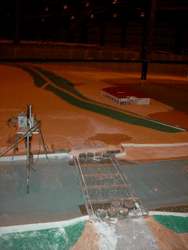
An Army Corps of Engineers task force is testing various factors that could have affected the performance of the levee system, using this 1:50 scale model of the 17th Street Canal and the New Orleans Lakefront. (Photo: Molly Peterson)
SHARP: Because it has a sand foundation. Whenever water can get to the sand then the pressure in the sand increases very rapidly, and that was a critical factor in the failure at London. The crack formed, the water could get down to the sand, the pressures of the water went very high and it basically just kind of lifted up the whole levee and lost all of its weight and its ability to resist any load. And it just kind of floated away.
PETERSON: At 17th Street there was also a layer of weak clay down below. Sharp believes that’s the reason the wall buckled and jumped 35 feet out from where it stood. There’s no agreement yet on the failure of these crucial canal walls. A team from UC Berkeley, funded also by the National Science Foundation, took its own soil samples at 17th Street, cores 20 to 40 feet deep. I caught up with UC Berkeley team leader Ray Seed as he was grabbing breakfast. He says his samples found something the Corps missed: runny material left behind by an earlier hurricane.
SEED: It’s hidden at the base of a whole mat of one-to-several inches of leaves and twigs and sticks that came down, probably during the same hurricane and mixed in with the layer. So it’s very difficult material to get a hold of.
PETERSON: Seed believes that unstable deposit is the reason the wall slid out like a greased pan. He says the Corps should do more sampling to make sure the same layer won’t fail again. Seed’s team is one of several doing separate investigations. Louisiana funded another, the National Academies of Science will make conclusions, too, and the Army Corps even has its own external review panel to double-check its work. Seed says the levees should be engineered to a level of risk 100 to 1000 times lower, more like dams.
SEED: The reason dams are treated so safely is because they threaten large populations when they fail. Current levee policies revolve in the 1930s and 1940s at a time when most levees in the United States protected cows and fields.
[17TH STREET CONSTRUCTION, BEEPING]
PETERSON: The Corps has been racing to finish one set of new projects aimed at upping the safety factor in New Orleans: it’s putting in gates at the top of the drainage canals where they connect with the lake.
[17TH STREET CONSTRUCTION, BEEPING]
PETERSON: During Katrina, water funneling in from the ocean came in through man-made channels and piled up in Lake Pontchartrain. Now Corps crews will block the water with long sheets of steel that cranes drop into the earth.
[SHEET PILE SLIDE…ABRUPT METAL SLIDING SOUND…METAL CHAINS CLANKING]
PETERSON: Crews vibrate the steel down into place. Tall enough to withstand waves and deep enough, engineers think, to stop water from seeping through sand underneath.
[SHEET PILE SLIDE AND VIBRATIONS, RAPID KNOCKING THAT COMES TO AN END]
PETERSON: It’s an engineering solution found commonly in the Netherlands, a country that’s battled storms and rising seas for a thousand years.
Dutch Engineer Jurjen Battjes says building gates to protect drainage canals in New Orleans from storm surges is only common sense -- he says the water is like an enemy, trying to invade your territory. (Photo: Molly Peterson)
PETERSON: That’s Jurjen Battjes. He’s a Dutch engineer, part of the panel reviewing the Army Corp’s work. He nods approvingly at the site. It reminds him of larger and more expensive projects the Dutch have built. Battjes says putting gates in here at 17th Street is only common sense.
BATTJES: The very first thing I asked, why are the pumping stations at the south end? And are these canals open? Because it’s so logical to keep the high water threat out of these canals by having a control gate at the lakeshore because it is relatively easy to close them off at the lake side.
PETERSON: Corps officials had planned to finish these temporary barriers by the first of June, but now they’re saying mid-summer. Corps project manager Chris Gilmore says there’s lots of reasons for the delay– everything from real estate access to wind blowing the sheets of steel around to materials they are finding at the site.
GILMORE: Right now there’s no telling what it’s going through in this area right here. I know when we first started driving it, it was having trouble going through woody debris, stumps and things like that. We’ve actually come in and excavated out to get below that.
PETERSON: Until engineers know more about the strength of the canal walls and until there is full pumping capacity again–the Corps and the city’s sewer board will have to keep careful watch on water levels.
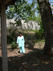
Mary Ann Francois stands at the back of her property, where she noticed subsistence. Her house backs right up on the London Avenue Canal. (Photo: Molly Peterson)
FRANCOIS: Once you see something for a long time, it disappears. And that’s how I reacted to the floodwall behind me. I got so used to it being there. Until it started causing soil subsidence and things like that to the property, I just didn’t notice it, to be honest with you. And many trees and the shrubbery blocked the view.
PETERSON: But Francois did see her driveway cracking, the earth sinking, where water ponded. She didn’t wait for trucks from the local levee board. She brought in eight 12-foot dump trucks of dirt herself. Of course, it didn’t work. The ground is still sinking. And she says she doesn’t think she can risk living here again.
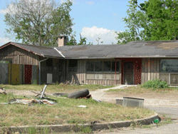
After Hurricane Katrina hit, the Cypress-framed home Mary Ann Francois lived in for 30 years was flooded with over eight feet of water. (Photo: Molly Peterson)
PETERSON: The Corps has been identifying more weak spots throughout the region that will need attention. It’s planning a map to tell people where the problems are. Until that’s ready, the hope this storm season is that residents, like the system’s architects, know more than they used to – and that they’re more on guard. For Living on Earth, I’m Molly Peterson in New Orleans.
CURWOOD: For more details on the levee failures, go to our website, loe.org. That’s loe.org.
Links
U.S. Army Corps of Engineers Hurricane Recovery site
New Orleans District Task Force
Video of New Orleans Levee Model Illustrating IPET Preliminary Findings
University of California at Berkeley press release of final report
Living on Earth wants to hear from you!
Living on Earth
62 Calef Highway, Suite 212
Lee, NH 03861
Telephone: 617-287-4121
E-mail: comments@loe.org
Newsletter [Click here]
Donate to Living on Earth!
Living on Earth is an independent media program and relies entirely on contributions from listeners and institutions supporting public service. Please donate now to preserve an independent environmental voice.
NewsletterLiving on Earth offers a weekly delivery of the show's rundown to your mailbox. Sign up for our newsletter today!
![]() Sailors For The Sea: Be the change you want to sea.
Sailors For The Sea: Be the change you want to sea.
 The Grantham Foundation for the Protection of the Environment: Committed to protecting and improving the health of the global environment.
 Contribute to Living on Earth and receive, as our gift to you, an archival print of one of Mark Seth Lender's extraordinary wildlife photographs. Follow the link to see Mark's current collection of photographs.
 Buy a signed copy of Mark Seth Lender's book Smeagull the Seagull & support Living on Earth
© Copyright World Media Foundation. All Rights Reserved
Home | Contact | RSS | Donate | Newsletter