
Global Warming & Harvey
Air Date: Week of September 1, 2017
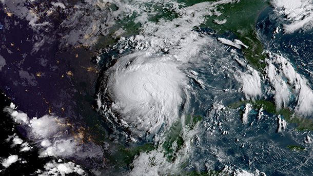
Harvey as viewed from space on August 24th, just before strengthening into a hurricane. (Photo: NOAA/NASA GOES Project, Flickr CC BY 2.0)
A warmer world is a rainier world, as warmer air holds more moisture. The exceptional warmth of Gulf of Mexico waters in 2017 helped fuel Hurricane Harvey’s deluge, Kevin Trenberth, senior scientist at the National Center for Atmospheric Research, tells host Steve Curwood. They discuss how new satellite and imaging technology helped accurately forecast Harvey’s ferocity. But proposed cuts to federal funding for key technology could hinder future efforts to prepare for extreme weather.
Transcript
CURWOOD: It’s Living on Earth, I’m Steve Curwood.
Hurricane Harvey has been called “unprecedented”, which is prompting questions about the role of global warming in its record-breaking rainfall. So we called up Kevin Trenberth, a distinguished Senior Scientist at the National Center for Atmospheric Research in Boulder, Colorado, to find out what he thinks.
Kevin, welcome back to Living on Earth.
TRENBERTH: It's nice to join you again although these circumstances might be better, I suppose, in Texas.
CURWOOD: What is so unprecedented about this storm system?
TRENBERTH: Well certainly it's broken many records, evidently, in terms of the total rainfall, both the extent and the amount at individual locations. Many places topping over 40 inches. The storm itself has broken records. It developed to a category four storm, even though it was in a location that wasn't ideal for a strong development. It was quite close to land when it did that, and then, when it moved over the land, it stayed active for something like 70 hours before it went back over the ocean; whereas, these storms usually die out once they go over land and the average lifetime of these storms over land is about 27 hours or something like that. And so, it was able to sustain itself because it was so large and all of the moisture that was flowing in from the Gulf kept refueling the storm, so to speak, and of course, at the same time, absolutely drenching Houston.
Time-lapse of Hurricane Harvey’s destructive path through Texas. (Produced by KXAN)
CURWOOD: So, why? Why was it able to go back out to sea and get more energy and keep going?
TRENBERTH: So, the gulf has been very warm. This is, of course, the time of year - peak summer - when the sea surface temperatures are at their highest. They're normally getting up to about 85, 86 degrees, and this year there are over a very extensive area, 87 degrees Fahrenheit. So, there's very warm water out there, anyway.
It's warmer than normal for two reasons: one, there is a natural variability component which may actually relate to things like the El Nino last year and the year before in the Pacific that suppressed activity in the Atlantic, and then there's also the climate change aspect. So, the sea temperatures are higher because of climate change, and so there is tremendous amounts of warm moist air over the Gulf. The rule of thumb is, for one degree Fahrenheit there is five percent more moisture in the atmosphere. And so a couple of degrees above normal means there is 10 percent more moisture in the atmosphere, and this is adding then to the fuel that's available for the storm. And, of course, it adds to the rainfall as well.
CURWOOD: In other words, what goes up in the form of moisture must come down.
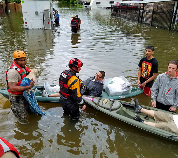
The Texas National Guard rescues residents flooded out by Hurricane Harvey. (Photo: Staff Sgt. Tim Pruitt / National Guard, Flickr CC BY 2.0)
TRENBERTH: Yes, and so, when the moisture rains out, it gives back the heat that went into evaporating in the first place. That's the fuel for the hurricane itself, and so it's been able to refuel itself especially through the spiral arm bands that are surrounding the storm, and one of these spiral arm bands was sort of stuck right over Houston, and the moisture was just continuing to flow over land, long after the storm made landfall. And so this is what helped to sustain the storm, but it related very much to the fact that it was it was quite a large storm also.
CURWOOD: So, what's going on around the world? We saw those huge floods in California, but there's things going on in Asia right now. Talk to me about that.
TRENBERTH: Yes, and so the monsoon has been very active and there's been a tremendous amount of flooding in the mountains in Nepal, in India, in Bangladesh, from mid-July up until the present, and there have been something like 1,000 deaths over and that region. We don't see much of it in the news on a day to day basis here because we're so preoccupied with stuff that's going on in our own country, but it's not an unrelated phenomenon.
CURWOOD: Talk to me about the hurricane modeling and how it might have changed since Katrina which is now 12 years ago. What tools are meteorologists able to use today, in terms of getting a bead on a storm system that could really blow up in what we've seen in South Texas?
TRENBERTH: So, in the first place, of course, there is new technology in space and there's some new satellites that have just gone up and NOAA has been using this so-called GOES satellites. These are the geo-stationary satellites, but they have a much more rapid cycle time and also much higher resolution, and so the details that you can see and the movie loops that they can produce on these things are absolutely remarkable and certainly much better than we had back in 2005.
And then, secondly the computers have gotten bigger and faster and one of the main results from that is that we can now run our models at quite a bit higher resolution. We still really need to get down to a much higher resolution, to really do these things well, and, so, computer limitations are still a factor on this but certainly hurricane models that are not doing these things globally are running at quite high resolution and the forecasts for this event were remarkably good.
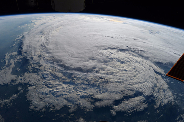
Astronaut Randy Bresnik captured this photo of Hurricane Harvey from the International Space Station on August 28th, 2017. (Photo: Randy Bresnik / NASA, Flickr CC BY 2.0)
CURWOOD: Kevin, President Trump's budget proposes cutting funding for satellites and other aspects including the entire NOAA - National Oceanic and Atmospheric Administration - budget. How could cuts to weather and climate data gathering satellites and systems impact the reliability of models and forecasts?
TRENBERTH: Yes, there's been some emphasis on improving weather forecasts in the Congress, but the climate cuts are potentially devastating because the way to really improve weather forecasts, especially when, on the extended rain, say going out beyond a week to a month or something like that, really involves what we would call climate process. It's the interactions between the atmosphere and the ocean and the, and the atmosphere in the land that we need to improve in our forecast models, and as part of the climate program and NOAA, all of the ocean observing system is paid for out of that. Knowing what is going on below the surface, which is the ocean heat content that supports the sea temperatures and which is up-welled to the surface and stirred up by hurricanes, knowing just what's going on there is absolutely vital information. So, it's quite short-sighted to cut the information that's really available. You know, it's one thing to have information. It's another thing as to what you do with that information, but let's at least get the information.
CURWOOD: Worldwide, how prepared do you think major cities are for the increased precipitation that can be seen in storms like Harvey for rain or, I guess, there are snow events as well?
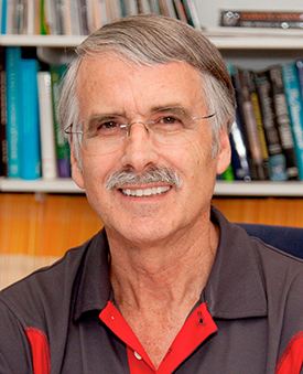
Kevin Trenberth is a distinguished senior scientist with the National Center for Atmospheric Research. (Photo: National Center for Atmospheric Research)
TRENBERTH: So, with climate change there are two things one would like to do. One is to slow down the process or stop it from happening in the first place. The second thing is to recognize that it's happening and adapt to it, and this means building resilience in particular, recognize that the threat from storms for flooding is much greater than it used to be. And so, we're seeing reports of thousand-year storms and certainly this is one. We had a couple last year with the Louisiana floods just over a year ago and also Hurricane Matthew in the Carolinas.
The statistics suggest that these were thousand-year storms. But these days they're really not. Because of climate change, they're more like 70 or 100 year storms. They're still relatively rare events and they're certainly extreme events, but their odds are actually increasing because of climate change.
Are cities preparing for this? Not adequately, nowhere. We're not doing enough to stop the problem and we're certainly not doing enough to prepare for it. All of these events these days have a component relating to climate change, which has a human component. It may be a relatively small fraction. It may be 10, 15 percent, something of that order. But, when you have an extreme event that's already going on, that extra 10 percent can push you across various thresholds, and once you cross these thresholds, things break. And we're seeing that more and more, in the US, where we've got very good infrastructure in general, but this is also true in other parts of the world.
CURWOOD: Kevin Trenberth is a distinguished Senior Scientist at the National Center for Atmospheric Research in Boulder, Colorado. Thanks so much for taking the time with us today.
TRENBERTH: Thanks it's been good to be with you.
Links
Time: “A Timeline of Hurricane Harvey’s Development”
A previous LOE interview with NCAR Senior scientist Kevin Trenberth
Living on Earth wants to hear from you!
Living on Earth
62 Calef Highway, Suite 212
Lee, NH 03861
Telephone: 617-287-4121
E-mail: comments@loe.org
Newsletter [Click here]
Donate to Living on Earth!
Living on Earth is an independent media program and relies entirely on contributions from listeners and institutions supporting public service. Please donate now to preserve an independent environmental voice.
NewsletterLiving on Earth offers a weekly delivery of the show's rundown to your mailbox. Sign up for our newsletter today!
![]() Sailors For The Sea: Be the change you want to sea.
Sailors For The Sea: Be the change you want to sea.
 The Grantham Foundation for the Protection of the Environment: Committed to protecting and improving the health of the global environment.
 Contribute to Living on Earth and receive, as our gift to you, an archival print of one of Mark Seth Lender's extraordinary wildlife photographs. Follow the link to see Mark's current collection of photographs.
 Buy a signed copy of Mark Seth Lender's book Smeagull the Seagull & support Living on Earth
© Copyright World Media Foundation. All Rights Reserved
Home | Contact | RSS | Donate | Newsletter