Toxic Trailway
Air Date: Week of August 6, 2004
Producer Guy Hand rides a new bike trail through the famously polluted former mining regions of North Idaho. The trail is a recreational Superfund site, designed by the EPA.
Transcript
CURWOOD: It’s Living on Earth, I’m Steve Curwood. Throughout the West communities are trying to build new, recreation-based economies over the old ones based on mining. The Trail of the Coeur d’Alenes is a literal example. This new bike trail in North Idaho converts an old mining-era rail line to recreational use. It’s one of the longest Rails to Trails projects in America.
But beneath the miles of fresh asphalt there’s also toxic mining debris strewn the length of the line. Indeed, some call it a recreational Superfund site, a trail for bikers, hikers and skaters built to contain contaminants and promote tourism. Producer Guy Hand cycled the Trail of the Coeur d'Alenes to see if this exploited piece of the American west can bury its past and pave the way to a brighter future.
[BANJO MUSIC AND CROWD NOISE]
HAND: It's not surprising that when the Coeur d'Alenes bike trail officially opened in June, people in the North Idaho mining towns that dot it's path were ready to celebrate.
SIJOHN: Okay, ladies and gentlemen, we're getting started here.
HAND: This 72-mile long black strip of asphalt running through the mountains is a symbol of hope for residents who've been living under the label "Superfund Site" for over 20 years—a label that many says has been toxic to tourism despite the region's stunning beauty.
MOORE: And today on behalf of Union Pacific I'd like to present to the citizens of the entire Pacific Northwest, the state of Idaho, and Coeur d’Alene tribe, I present to you the Trail of the Coeur d’Alenes.
[CLAPPING]
HAND: Ed Moreen is project manager with the Environmental Protection Agency.
MOREEN: When we were still constructing the trail, it was evident that the people in the basin were excited about the trail. In fact, when the contractors were placing the asphalt, it was still steaming and people were right behind the paver wanting to ride down the path on their bikes.
[SOUND OF DERAILLEUR SPINNING, PREPARING TO RIDE]
HAND: At the trail's eastern end, where I begin my bike ride, the rail line doesn't hide its polluted past. A sign explains how tailings laced with lead, cadmium, zinc, and arsenic were used to build the rail bed itself. Ore dust also drifted out of open or damaged rail cars. It spilled from derailed ones. It piled up in loading areas. Over a century, heavy metals so contaminated the rail line that in places soil measured 80 times the EPA safe lead level.
[SOUND OF MOUNTING BIKE, SHIFTING GEARS THEN RIDING]
HAND: This part of the trail goes right through the mining town of Kellogg. This is the town that is home to the Bunker Hill Mine and Smelter, where some of the worst pollution occurred during the mining era. You can see on the hills around the town the trees are still stunted from the tainted smoke that came out of the smelters.
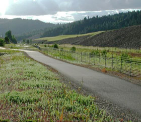
The trail flanked on both sides by piles of mine waste in the town of Kellogg, Idaho. (Photo: ©Guy Hand Productions)
[BIRD SONG]
HAND: But soon the trail leaves the more obvious signs of mining pollution behind and rolls through a landscape that looks pristine, but still isn't. Lead concentrates under this part of the trail average nearly 8,000 parts-per-million, or eight times the Superfund site's safety standard.
HAND (ON BIKE): Gorgeous meadows off to my left.
HAND: The stubborn beauty of this place—the steep mountains, lush meadows, and shimmering waterways—has the power to wash away concerns about lead tainted soil. And that's just fine with Joe Peak, a businessman with high hopes for the economic future of these mining towns.
[BAR CROWD, CASH REGISTER]
HAND: The bike trail runs right in front of Peak's bar and restaurant, The Snake Pit.
PEAK: Right outside we have two bike racks and those bike racks on weekends are full. Usually on Saturday afternoons and Sunday afternoons it's not unheard of for 50 to 60 percent of our business to be trail related. Let me get some customers…
HAND: Peak's a little distracted on this early Saturday evening. The place is packed. He figures the trail is adding a hundred thousand dollars a year to his business.
PEAK: We could get anywhere from 75-150,000 visits per year and we feel that the spin off on that could be as high as $14 million a year in the Silver Valley and the corridor from Mullen to Plummer.
Need some change?
[BAR SOUNDS, THEN BIKING]
HAND: Just west of Peak's place the trail heads into some of the most stunning country of the ride.
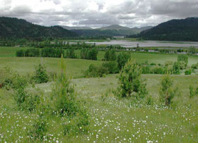 The bike trail runs through this landscape. (Photo: ©Guy Hand Productions)
HAND: A little further along I meet a young woman pulling her son in a kid cart behind her bike.
HAND: Hi. Do you ride the trail very often?
WOMAN: No, this is my first time on the trail. I'm actually from Colfax, Washington.
HAND: Oh really? Who's riding in back?
WOMAN: This is Adam. He is two years old. So he's not quite ready for a bicycle yet.
HAND: So what do you think of the trail?
WOMAN: Oh, I like it. It's great. How do you like the trail?
HAND: I think it's amazing. It’s gorgeous.
HAND: I find myself forgetting that just under the 2 1/2 inches of asphalt I glide over there's lead, arsenic, and more. Lead is a neurotoxin. It impairs cognitive abilities, especially in children. Arsenic, a potent carcinogen, can cause skin lesion and cardiovascular problems. But the EPA says the trail is perfectly safe. As long as you obey the occasional signs warning you to clean your hands before eating, stop only at designated rest areas, and stay on the asphalt.
[RIVER SOUNDS]
HAND: Yet, it's tempting to wander off. On this hot afternoon, a dip in the cool Coeur d’Alene River is hard to resist. The river and lake parallel nearly the entire length of the trail, but hold some of the highest concentrations of mine poisons in the nation. Still, a little further along, I see two young girls fishing, ankle deep in the river.
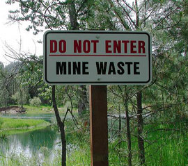 A warning sign on the trail with the Coeur d’Alene River in the background. (Photo: ©Guy Hand Productions)
HAND: Clifford Villa, assistant regional council for the EPA says that it's often easier to control the human usage of a contaminated area than to remove the contaminants themselves. It's an approach the EPA has employed at Love Canal and many other national Superfund sites. And here, when EPA determined it was impractical to remove the entire 72 miles of railbed contamination, a bike trail capping the problem seemed the best solution.
VILLA: One thing that the Rails to Trails program allows us is to insure the use of an area for recreational purposes. We actually did a risk assessment before the trail was constructed that estimated that people could use the trail up to 24 hours per week. That's some pretty intensive running or biking without any cause for concern about existing contamination.
HAND: But what about those two girls I saw fishing off the trail?
VILLA: Before the trail was built, people were using this corridor anyway. So we know people were here and we’re not going to keep people off. We're just going to try to control that use and promote safe uses as much as possible.
HAND: Villa says the EPA can't eliminate all risk, but since people are going to use the area anyway, he believes the trail has made things much safer. In fact, he considers the trail one of his biggest Superfund successes.
VILLA: It's very satisfying to not only take something away in the form of contamination, but to leave something behind in terms of something that all the people of this area can appreciate from here on.
[OUTDOOR SOUNDS]
SCHLEPP: As you can see, the trail actually comes by our hay shed there…
HAND: Farmer Mike Schlepp shows me where the trail of the Coeur d’Alenes cuts through his 550-acre farm at about mile post 33. He's a vocal critic of the trail and doubts the wisdom of attracting tourists to a Superfund site.
SCHLEPP: All of us landowners have had problems with people getting off the trail and wandering on to private property.
HAND: The EPA's own study admits that the trail will probably entice visitors to pick berries and wander off trail to hike, fish, or swim. The study says those quote off-trail exposures fall beyond the scope of the trail plan.
SCHLEPP: We actually had a family that left the right of way and were attempting to set up an overnight camping spot with their children. One of the children was still an infant. And we did explain that they were actually having their children recreate on a heavy metals site and asked them to leave and really they were quite belligerent. Regretfully, they just went down the trail about a mile and a half and set up camp for the night just off the right of way.
HAND: The EPA says trail managers will catch violators like these, but Schlepp argues that the former owner of the line, Union Pacific railroad, should have removed the contamination altogether—just like any other landowner.
SCHLEPP: I have not seen anywhere in Superfund law that it says that if a polluter can actually make the problem big enough that he can be relieved from cleaning it up because it's just too big.
HAND: The EPA is expanding its Superfund work from the worst hit mining towns to the entire basin. But now that the railroad is enshrined as a bike trail, the cleanup Schlepp hoped for will never reach his property. He says that every time it floods, and it floods frequently here, the contaminants contained in the trail get flushed into his fields.
SCHLEPP: They will eventually have the entire basin cleaned up except for this 150-foot wide swath of contamination that goes right through the underbelly of the basin.
[SOUND OF BIKE RIDING]
|
|
TONI HARDY: The reality is this trail locks in a solution that we find unacceptable. This is a Superfund. It's not a recreational trail. It is a Superfund. HAND: Rog Hardy says the bike path just doesn't properly cover a contaminated railroad that, like a Mayan pyramid, is flat and narrow on top but has exposed sides sloping out to a much broader base. ROG HARDY: Well as you can see standing here, the asphalt is only about 10 feet wide and by the time you get down to the base of it, it's about a hundred feet wide, so you've only really capped about 10 percent of it. The rest of it is subject to rain and snow melt washing this stuff out into the lake and wetlands. HAND: The EPA covered the sloping sides with a thick layer of crushed rock. And Hardy agrees that trail users are at little risk as long as they heed warning signs. His concerns are for those who live along the trail. ROG HARDY: It's absolutely correct that the people that live here, that will continue to play as their predecessors have in the beaches, are going to get their dose of lead that's being supplied by these causeways that are being frozen in place. HAND: And what about those residents who don't read -- like ducks? [WATER SOUNDS, FLAPPING WINGS, QUACKING] HAND: Dan Audet, Environmental Contaminant Specialist for the U.S. Fish and Wildlife Service. AUDET: We're collecting blood samples from the waterfowl, which we'll analyze for lead. In addition we're looking at the sediments where the birds are feeding because these birds ingest sediment as they are feeding on various plants in the wetlands system. HAND: Lead kills tundra swans, Canada geese, wood ducks, pintails, mallards, and more. AUDET: We've had 12 species documented over the years that have died from lead poisoning. We suspect that hundreds of birds each year die from lead poisoning that are never found. HAND: But since the railroad is only one of many sources of mine pollution in the basin, no one knows to what extent the trail is poisoning an already poisoned watershed. Audet hopes to find out. AUDET: There are areas that seem to be leaching into the lake and whether those are truly contaminated, we hope to get a better handle on what the sediment concentrations are this year through this study. HAND: If sediments are leaching, the EPA says it will adapt, and manage the trail differently. But critics argue that Superfund is seriously underfunded and the EPA is under considerable pressure from Idaho politicians and business interests to play down the pollution problem. Critics say the EPA rushed to cover the railroad's past with a thin layer of asphalt. [SOUNDS OF BIKE RIDING] HAND: Toward its west end, the trail enters Native American land where people are in no rush to cover up the past. In fact, for the Coeur d’Alene tribe, the trail was a footpath long before the mining era. Robert Matt of the Coeur d’Alene Tribe: MATT: That entire watershed was our homeland. And when the government in the early 1900s, when they started taking our lands from us, there were promises that were made to the tribe about preserving the integrity of the resources and we would forever be able to have our traditional way of life preserved. Well, today many of those traditional uses and opportunities have been eliminated by the mining contamination and by the sediment. HAND: In a sense the tribe created the new bike trail as well as the ancient footpath. In 1991 it was the Tribe who sued Union Pacific Railroad and mining groups, demanding a clean up of the entire basin, including the total removal of railway contamination. Though that goal is still far off, it jump started the notion of a bike trail. Matt says the tribe sees the path not as a way to bury the past but as a way to confront it—with signs and kiosks on the tribal section of the trail that illustrate the need for further cleanup. MATT: Sometimes the information that needs to be put out isn't always attractive for tourists or economic development opportunities and those sorts of things and that's where we tend to get crossways with folks. But we're insistent that all the facts get put out and that people are made aware and we do that in hopes of finding support for clean up. [INDIAN MUSIC] HAND: At the western end of the Trail of the Coeur d’Alenes, tribe members are celebrating the official opening of the trail. SIJOHN: There's so much strength, and there's so much power in this trail. I looked at the faces of my own children, I look at the faces of the children of the Silver Valley, and they have hope now. HAND: The Trail of the Coeur d'Alenes offers both hope and a very good bike ride. The two kind of go together. After all, you can't help but feel encouraged with a warm breeze and beautiful scenery sliding by. But as I bike this basin I'm also struck by how — compared to the mountains and valleys around me—how ephemeral, how fragile this trail seems. It's not a work of geology, yet we hope it will act like one, that it will withstand time, rain, and erosion with the patience of granite. The Union Pacific Railroad promises, as part of its agreement with the EPA, to maintain the trail forever. But that's a very long time. Here in the Coeur d'Alene basin, we've created a pollution problem that some say could last for centuries. We can only hope that our solutions are as enduring. [MUSIC] Living on Earth wants to hear from you!Living on Earth Newsletter [Click here]
Donate to Living on Earth! NewsletterLiving on Earth offers a weekly delivery of the show's rundown to your mailbox. Sign up for our newsletter today!
|

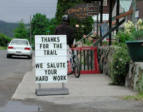 A sign praising the trail in the village of Harrison, Idaho. (Photo: ©Guy Hand Productions)


