Redlining Linked with Extreme Urban Heat
Air Date: Week of January 24, 2020

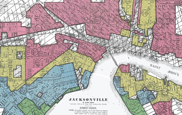
Jacksonville, Florida has a long history of segregation. (Photo: Digital Scholarship Lab)
In the 1930s, while the world was digging out of the Great Depression, the US government came up with a plan to rate neighborhoods based on their presumed suitability to receive home loans. The neighborhoods that the government, and banks, considered riskiest were outlined in red. These “redlined” neighborhoods tended to be in city centers and home to black Americans. Today as climate change exacerbates urban heat, they’re experiencing much higher temperatures than surrounding areas. Vivek Shandas is a lead author of the research and speaks with Host Bobby Bascomb about the unequal impacts of racist ‘redlining’ practices.
Transcript
BASCOMB: In the 1930s, while the world was digging out of the Great Depression, the US government came up with a plan to ostensibly advise banks on better ways to lend money to would be homeowners. The federal government drew up maps of more than 200 cities and gave grades to individual neighborhoods based on their suitability to receive a loan. A-grade areas were outlined in green. They were largely suburban and white. On the other end of the spectrum, D grade neighborhoods were outlined in red. They tended to be in city centers and black. In fact, minority neighborhoods were more likely to be inside a red line despite similar household incomes, home age, and other risk factors in white communities. In a practice that came to be known as redlining, banks used the government’s racist recommendations to deny home loans to minority residents. Nearly 100 years later the legacy of redlining is still evident today in a myriad of ways, including the exacerbated effects of climate change. In a recent study published in the journal Climate, researchers found that redlined neighborhoods, still today predominantly made up of minorities, are up to 10 degrees hotter than other neighborhoods in the same city. A lead author of the study is Portland State University Professor, Vivek Shandas.
SHANDAS: What we wanted to look at is just one climate, a new stressor that we know is going to increase in frequency, magnitude and duration over the coming decades and that's urban heat. Urban heat kills more people than all other natural disasters combined in the U.S. and it particularly is a very selective killer in that the people who have died have been historically underserved communities, historically, black communities. And so we wanted to see was that policy that was fundamentally based on race and social class was that playing out to affect the communities today in terms of who's exposed to those intense heat waves at a much higher magnitude than others. And what we found was that pretty much across the country in the hundred and eight cities, we looked at those areas that were hotter, were those redline neighborhoods.
BASCOMB: And to be clear, I mean, this is the same city we're talking about. So you're sitting in Portland, Oregon, which I believe was the city with the highest discrepancy of temperature in these redlined areas versus non-redlined areas. But why is that? I mean, why within the same city are you seeing such a dramatic temperature difference?
SHANDAS: The temperature differences are largely a factor of differences in the physical environment. So, what is in those neighborhoods now that were formerly redlined. And what we see consistently is that those neighborhoods are often either right on top of or adjacent to industrial areas. Those areas are often where the biggest freeways or highways were put in, in the 1950s. We see those areas is often having a lot fewer trees and a lot more impervious surface or that kind of concrete or asphalt that really absorbs heat over time. And so this is a phenomenon that is consistent across these cities we looked at and these historically, redlined areas have the built environment that absorbs the sun's radiation and amplifies temperatures a lot more. And as you were saying Portland, Oregon is top of the list though, Denver, Minneapolis, Columbus, Jacksonville, Philadelphia, Louisville, Baltimore. They're all in that top range of cities as well.
BASCOMB: Well, what kind of effects do you see in communities that are hotter than others? I'm thinking of even crime. I mean, I know I get cranky when it gets hot out. And we routinely see spikes in crime rates in cities, particularly when it gets really hot. Do you think that any of that can go back to this policy?

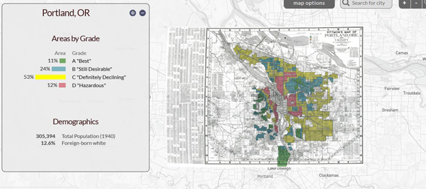
Only 11% of Portland, Oregon was considered desirable for mortgage loans between 1930 and 1940. (Photo: Digital Scholarship Lab)
SHANDAS: Yeah. So we've seen that people's behavior changes when it gets hotter. We've seen for example, more use of energy, we've seen greater hospitalizations, we've seen more issues of road rage and violence that happen when things get hotter in cities. And what that really comes down to is our mental health ability to cope as well as our physiological ability to cope and health impacts from increased heat as well. So we can talk about children that are exposed to heat. We've seen studies come out about how children at school are not able to focus are not able to actually do well and learn as a result of hotter classrooms or hotter environments. And so that can have a long-term effect on an ability to actually complete school. And that leads to a whole series of outcomes as well. We see this playing out in terms of our financial health; people are running their air conditioner much harder if they have access to air conditioning and have financial resources to run it. So that's money that's going away from other things like food or education or health that can be some of the basic needs for a community. And then of course, we have older adults, particularly those that have pre existing health conditions like asthma or any kind of heart condition. We've seen more recent work that's been done on stroke, brain health, in terms of heat, and that can have profound effects as well. Working with some folks at UCLA Medical School to try to better assess some of those impacts and there's no shortage of heat and health related impacts that are occurring.
BASCOMB: We had a story on the show recently, in which we talked a bit about the dramatic difference between white and African American babies and infant mortality rates. And the statistic that really struck me is that a black woman with an advanced degree is more likely to lose her baby than a white woman with an eighth grade education. So it's not about affluence. It's not about, you know, education. To what degree is it possible that living in hotter communities is putting a physical stress on pregnant African American moms and resulting in higher infant mortality rates for them?

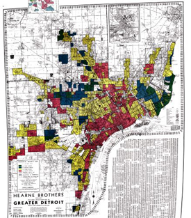
Map of redlined areas in Detroit from 1940: 6% were considered desirable (marked in green), 14% was considered still desirable (marked in blue), 51% were considered declining areas (yellow), 28% were considered hazardous (pink). (Photo: Digital Scholarship Lab)
SHANDAS: Right. Fascinating question about the relationship between race, health and climate and a lot of the study really has some potential directions. While we don't study that in this work right here, I will say that with redlining, we find that the communities living in historically redlined areas are still communities of color are still immigrant communities are still indigenous communities and, in part what that suggests is that if you have communities of color, like a black woman living in a formerly redlined area, what you're going to see is temperatures that are sometimes five eight, ten, twelve and we've even documented air temperatures of 20 degrees hotter in particular parts of a city. So, if you're talking about a 90-degree day for one part of the city, another part of the city could see 110-degree day. And once you cross that, around 98.6, about 37 Celsius degree our body is trying to cool down so our body uses sweat to be able to cool itself down. And I'm not a medical doctor though, I’m in collaboration with them. I've learned that this sweating process really helps us cool down though if the ambient temperature is hotter than 98.6 and if the humidity levels are high, we could reach this threshold called wet bulb temperatures, that's W-E-T B-U-L-B temperatures which are a point at which our body is unable to kind of cope and cool down. And so that stress that the body faces goes right into the womb that an unborn child is in and that's a level of stress that's part of that pregnant mother and that then affects the child. What we've seen in a project we're working on with five states and cities and five states where we're looking at birth outcomes in relation to heat and air quality, we've actually seen that the smallest babies have some of the biggest effects. So these are preterm births have some of the biggest effects from the mother being exposed to extreme heat and poor air quality. So what that means is that a child being born very small actually ends up being born even smaller as a result of this exposure. And the smaller the baby gets, the more that baby has to really struggle in order to be able to live and it leads to as we've learned from the field of epigenetics, long term consequences on the health and well being of that person. The effects of redlining then can really play out in terms of what the environmental conditions are that a person, let's say, in this case, a black woman is exposed to, and that can lead to long term consequences on their ability to manage their own as well as their children's health.
BASCOMB: Well, it's just, it's just shocking, really how, you know, a racist policy from, you know, almost a century ago, is persisting in so many different ways and has such long term health impacts on people that had nothing to do with that back then.

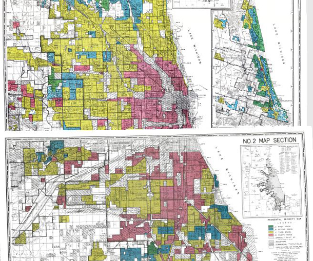
This is a map of the different levels of redlined areas in Chicago. The green areas represent desirable areas (A areas), the blue areas are still considered good but not a “hotspot” (B areas), the yellow C areas are considered declining areas, and the pink D areas are considered hazardous. (Photo: Digital Scholarship Lab)
SHANDAS: Right, right. And you know, in public health, it's a very common phrase now to be talking about your zip code is more important than your genetic code. And I've heard that said by a lot of very impassioned and very committed public health staff and various agencies and community health workers, etc. And what occurs to me is that the fact that your zip code is so important for your health and well being has a lot to do with how we're going about planning our places and planning our cities. And that's really what a lot of this work kind of comes back to is, how did this policy really underscore the racial underpinnings of the country.
BASCOMB: So for somebody that's listening right now and nodding their heads in Yeah, you know what it is hotter where I live, then where I work. Maybe I'm living in one of these communities that's suffering from these racist practices, what can you say to those people?

Vivek Shandas is a professor of climate adaptation at Portland State University and co-author in this study. (Photo: Vivek Shandas)
SHANDAS: Part of my job is to study cities. And I've heard a lot about people really pointing and blaming and saying, you know, I wish people in that neighborhood would take better care of their place, or I wish they would be more engaged, or I wish they would be doing things differently. And there's a lot of this, that I hear from communities that I talked to about blaming communities of being kind of, quote, sketchy or being, quote, not really worth visiting. And these are things that really hit me pretty hard, because I see through studies like the one we did, that this was a very systematic process that actually is no fault of the people that actually live there. And I guess that's really kind of at the core of what I'm hoping that this study will help reveal is that these are kind of underlying challenges that have been there and a long time. And our work then in front of us is to be engaged with the planning that's happening in our backyard with the planning that's happening all around us and to be kind of really mindful about the fact that the decisions made today could have repercussions twenty, fifty, one hundred years later, and to kind of go into this planning process thoughtfully and with recognition that these historical practices are things we have to undo and things we have to center in our current work, climate or otherwise.
BASCOMB: Vivek Shandas is a professor of climate adaptation at Portland State University and co-author of the recent study. Thank you so much for taking this time with me.
SHANDAS: Thanks so much for your interest.
Links
Click here for a virtual map of redlined zones across the United States
Living on Earth wants to hear from you!
Living on Earth
62 Calef Highway, Suite 212
Lee, NH 03861
Telephone: 617-287-4121
E-mail: comments@loe.org
Newsletter [Click here]
Donate to Living on Earth!
Living on Earth is an independent media program and relies entirely on contributions from listeners and institutions supporting public service. Please donate now to preserve an independent environmental voice.
NewsletterLiving on Earth offers a weekly delivery of the show's rundown to your mailbox. Sign up for our newsletter today!
 Sailors For The Sea: Be the change you want to sea.
 The Grantham Foundation for the Protection of the Environment: Committed to protecting and improving the health of the global environment.
 Contribute to Living on Earth and receive, as our gift to you, an archival print of one of Mark Seth Lender's extraordinary wildlife photographs. Follow the link to see Mark's current collection of photographs.
 Buy a signed copy of Mark Seth Lender's book Smeagull the Seagull & support Living on Earth

