
Climate Disruption Worsens Flood Risks
Air Date: Week of July 11, 2025
On the 4th of July, 2025, flash flooding hit Kerr County, Texas. A local river quickly rose over 20 feet in under an hour. (Photo: Courtesy of Louis Amestoy, The Kerr County Lead)
Catastrophic floods like the one that claimed at least 100 lives in Texas this July are becoming more likely because of climate disruption. Meteorologist Sean Sublette is the owner of Sublette Weather and Consulting. He joins Host Aynsley O’Neill to talk about the atmospheric and climate conditions that contribute to flood disasters, and the growing need to be weather aware
Transcript
O’NEILL: In recent days multiple catastrophic flooding events have hit rural communities in the US. Heavy rain in New Mexico triggered historic flooding in the mountain town of Ruidoso. Parts of Central North Carolina also experienced flooding. And on July 4th, the Guadalupe River in Texas rose more than 20 feet in under an hour, killing more than 100 people. And as we record this broadcast, many more are still missing. Sean Sublette is a meteorologist as well as a contributing author for our media partner, Inside Climate News and the owner of Sublette Weather and Consulting. He’s joining us now to talk about the atmospheric and climate conditions that contributed to these disasters, and the growing need to be weather aware. Sean, welcome back to Living on Earth.
SUBLETTE: Thank you so much. It's good to be back to talk with everybody.
O'NEILL: What's been going on here with these incredibly intense flash floods that have been happening across the US?
SUBLETTE: Yeah. So first of all, let's back up a little bit, it is summer and it is humid, so flash flooding is not uncommon to begin with. Having said that, because the climate is warming, a warmer atmosphere tends to hold more water, meaning it can evaporate more off of oceans, out of ground moisture, out of rivers and bays, so there is more moisture available to go into clouds and then ultimately back into rainfall, in this case, heavy precipitation. And we've got good evidence from the statistics and the data that the most intense rainfall is actually getting heavier over the past 30 to 40 years. So a flash flood event today is likely a little bit worse than a flash flood event than 40 or 50 years ago. So it is not the only thing, but is a contributing factor to the fact that things are kind of getting worse.
O'NEILL: And how does flash flood prediction sort of work? You know, how do we predict rainfall, where it's going to land, on what kind of surface? And how does that all come together?

Sean Sublette is a meteorologist with Sublette Weather and Consulting. (Photo: Courtesy of Sean Sublette)
SUBLETTE: Yeah, so that's the rub with flash flooding compared to, let's say, larger river flooding, like on the Mississippi or on the Charles or the Missouri rivers, that's a very different set of scale. So when we think about flash flooding, this is very heavy rain that probably covers a couple of counties or maybe a few square miles, and it lasts for two to four hours or so. So now we've got something that is shorter in time frame and is smaller in spatial scale. And these kinds of things are more difficult to predict than larger scale phenomenon. Like in the winter time, most of our weather is driven by larger scale features in the atmosphere. During the summertime, thunderstorms and the like, are driven by smaller scale phenomenon in the atmosphere. So when we think about computer models and trying to simulate these things mathematically, they are more difficult to simulate and as a result, they are more difficult to forecast precisely. The entire weather community knew that flash flooding was likely. The question was going to be, is it bad or is it going to be catastrophic? We wouldn't know that until it begins to develop and I don't mean that it's already on top of them, but normally, in a situation like this, you can get two to three hours of warning before the water truly becomes dangerous. For example, in Central Texas, the warning went out just after one o'clock in the morning, and then it was kind of upgraded to a legit emergency three hours later. So from my aspect, I wonder, were the people in harm's way even aware that they were in harm's way? Did they understand the risk to begin with? Whose responsibility is that to understand what that risk is? So this is not to lay blame on any one person, or certainly not blame the victims here, but there is kind of this loss of information from the forecasts and the warnings to the end user and to get them to take action. And I think that's where we see a lot of the miscommunication, and a lot of what went wrong is in that process.
O'NEILL: If you were in charge of revamping how we get these warning events and these alerts all throughout the country, what would be your ideal system for informing people?
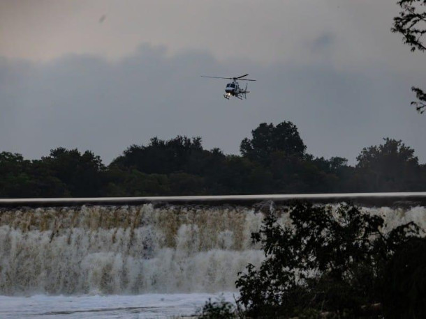
Search parties were able to rescue many of the victims of the flood. Despite their success, the death toll has reached over 100. (Photo: Courtesy of Louis Amestoy, The Kerr County Lead)
SUBLETTE: I don't think there's one perfect system at all, because we have a country that is rural. Some places it is very sparsely populated. Some places it is densely populated. Some places the cell coverage is good. Some places it's nonexistent. I think having a weather radio and being aware of the forecast every day is important, so you have an awareness of what your surroundings are going to be. So I think if we had a network where everyone was able to have a phone and get a reliable warning, that's great, but that costs a lot of money. I'm not sure how well that's going to be received. The weather radios are good, but they're not perfect either. I would tell people what I think most meteorologists would tell you and emergency managers: have two ways to get a critical weather warning and kind of be aware of your surroundings. There was a flood watch, which means conditions were favorable for flooding well ahead of the actual flood itself. So there are ways to raise awareness ahead of the event, before the event hits. But it's a question, does that message land where it needs to land, and what kind of actions are taken once the message is received?
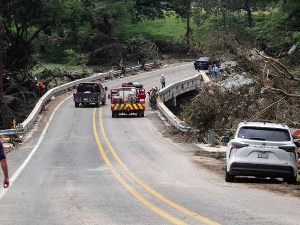
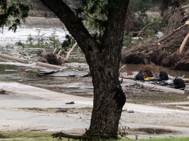
In addition to taking many human lives, the floods caused extensive infrastructure damage. (Photo: Courtesy of Louis Amestoy, The Kerr County Lead)
O'NEILL: Sean, I know that there have been recent federal budget cuts that impact weather tracking and disaster prevention. How have you been seeing that in your own meteorological experience?
SUBLETTE: I don't think that stuff has really percolated down just yet, it's still very new. I would kind of liken it to you've got a car and you just start ripping some parts out and you drive the car, it might be fine for a mile, 10 miles or 20 miles, but you know, if you took the lug nuts off the wheel, they might just fall off at any time. I think that's kind of where we are now. We're pulling things out of the car, and we're driving it along, and let's see what happens. That's kind of my concern right now, is we are taking safety nets, we're cutting holes in the safety nets right now, so we may not notice it right away. I don't think we can say that this tragedy was a direct result of the budget cuts. I do think the more you cut the budgets, the more you are raising your risk of tragedy. The weather service office was fully staffed that night, all right? There was no shortage of staff working that event that night. One position that I understand was vacant at that office was a position of Warning Coordination Meteorologist. And all of the Weather Service offices across the country, there's more than 100 of them that serve their local communities have a Warning Coordination Meteorologist, and his or her job is to literally do just that, coordinate warnings with local officials, county officials, emergency managers. Oftentimes, they will get on a call a few hours before an event takes place so that everybody is on the same page to like, hey, we really see a big flood threat coming today or tomorrow, you and your staff in your county or your town should be aware of it, and that's kind of how the whole process should start. And it's unclear to me if that happened or not, and maybe it did, maybe it didn't, but again, this is one of the more, this is just ripping another part out of a car before you drive it down the highway.
The Warning Coordination Meteorologist (WCM) position is a vital human communications link between the meteorologists at local NWS offices and local emergency managers.
If that position was vacant, it would have made it more difficult for emergency managers & the public to be aware of the threat.
— Sean Sublette (@subletteweather.com) July 8, 2025 at 9:52 AM
[image or embed]
O'NEILL: Sean, we're almost out of time here. Is there anything else you'd like our audience to know?
SUBLETTE: I would say, remain weather aware. There's weather in the short term and there is climate in the long term. Be aware of your surroundings. So oftentimes, we kind of get locked out of that. We're not paying attention to what's going on around us and this is, unfortunately, a very stark lesson in paying attention to your surroundings. Things that have not happened in the past are now starting to happen. I think about it statistically. If I took a pair of regular six sided dice and whatever kind of event that used to happen, let's say you would roll a 12, not something that happens often, but if you were to change one of the faces on those dice to a seven and get rid of the one, and you just roll it over and over again, most of the time, you still roll between a three and a 12, but sometimes roll a 13, which is like never happened before. So we need to be prepared for when the dice rolls a 13, something that has not happened before. Be aware of your surroundings. Be prepared for flooding, heat, in ways that maybe you didn't think of before and pay attention to those warnings, they can save your life. I do think it's important to understand that the climate is still warming and until we start moving away from fossil fuels for energy generation, transportation, industry, the climate's going to continue to warm, and we're going to have hotter days, heavier rain, and worsening droughts. And we need to be prepared for that, and we need to mitigate and adapt, in addition to trying to curb the warming as rapidly as possible.
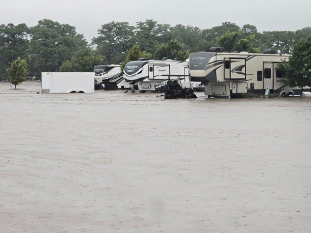
One of the hardest hit areas, in addition to a Christian summer camp, was an RV campground. (Photo: Courtesy of Louis Amestoy, The Kerr County Lead)
O'NEILL: Sean Sublette is a meteorologist and owner of Sublette Weather and Consulting. Sean, thank you so much for joining me today.
SUBLETTE: Thanks so much for having me, appreciate the time.
Links
Learn more about Sean Sublette
NPR | “Here’s a Timeline of the Catastrophic Texas Floods”
AP News | “What to Know About the Flash Floods in Texas That Killed Over 100 People”
The Weather Channel | “Satellite Images Show Devastation Of Texas Floods”
Living on Earth wants to hear from you!
Living on Earth
62 Calef Highway, Suite 212
Lee, NH 03861
Telephone: 617-287-4121
E-mail: comments@loe.org
Newsletter [Click here]
Donate to Living on Earth!
Living on Earth is an independent media program and relies entirely on contributions from listeners and institutions supporting public service. Please donate now to preserve an independent environmental voice.
NewsletterLiving on Earth offers a weekly delivery of the show's rundown to your mailbox. Sign up for our newsletter today!
![]() Sailors For The Sea: Be the change you want to sea.
Sailors For The Sea: Be the change you want to sea.
 The Grantham Foundation for the Protection of the Environment: Committed to protecting and improving the health of the global environment.
 Contribute to Living on Earth and receive, as our gift to you, an archival print of one of Mark Seth Lender's extraordinary wildlife photographs. Follow the link to see Mark's current collection of photographs.
 Buy a signed copy of Mark Seth Lender's book Smeagull the Seagull & support Living on Earth
© Copyright World Media Foundation. All Rights Reserved
Home | Contact | RSS | Donate | Newsletter