
Climate Monster in the Caribbean
Air Date: Week of October 31, 2025
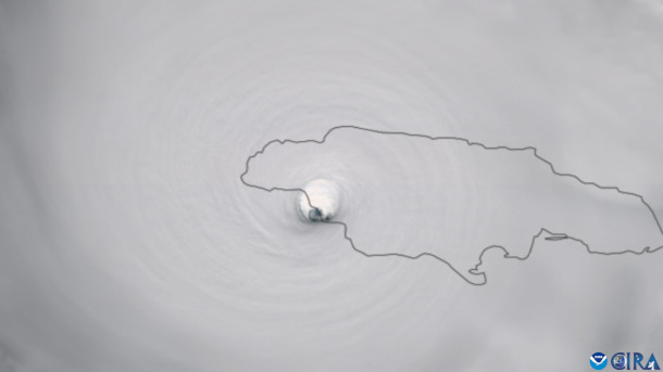
Satellite images track the moment Hurricane Melissa made landfall in the southwestern region of Jamaica. One of the most affected communities is Black River, where almost every home suffered damage and approximately 90% lost their roofs. Prime Minister Andrew Holness referred to this area as 'ground zero.' As of October 31st, an official death toll has not yet been announced. (Photo: CSU/CIRA & NOAA)
Hurricane Melissa, the strongest storm to hit the Caribbean in modern times, left a wake of destruction in Jamaica, Cuba and Haiti that will take years to recover from. Jamaican climate physics professor Tannecia Stephenson describes the toll of this climate catastrophe, and meteorologist Ryan Truchelut of the consulting firm Weather Tiger joins Host Jenni Doering to explain how the storm grew so ferocious in the blink of a hurricane’s eye.
Transcript
CURWOOD: From PRX and the Jennifer and Ted Stanley Studios at the University of Massachusetts Boston, this is Living on Earth. I’m Steve Curwood.
DOERING: And I’m Jenni Doering.
It will take years before the parts of Jamaica, Haiti and Cuba that were hit hardest by the deadly Hurricane Melissa will recover. The strongest storm to hit the Caribbean in modern times, the category 5 cyclone came ashore in the southwest of Jamaica at 185 miles per hour, shredding just about everything in its direct path.
CURWOOD: Tannecia Stephenson is a climate physics professor at the University of the West Indies in Jamaica. She says seeing the aftermath of the storm is heartbreaking and sobering.
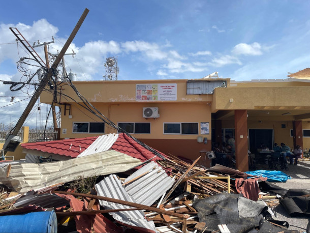
STEPHENSON: One of the, the main areas of impact was a parish called St. Elizabeth and for Jamaica, that's what we call our, the Breadbasket of Jamaica. A number of agricultural activities happen within that parish and sustain us as a country, and they were hit immensely.
DOERING: Black River and Montego Bay were among the places hit directly by the storm, but just about the whole island lost power and has yet to dry out from the torrential rains.
CURWOOD: And the damages from the catastrophic storm and the costs of recovery are estimated in the billions of dollars.
STEPHENSON: You know, as a small island within the Caribbean, you're between a rock and a hard place in terms of how does an island prepare for a category five storm? Immense preparations went in at government levels, organizational levels. The levels of individuals. And when you see our southwestern parishes and the impact of this storm, you know, one has to wonder, how do small islands contend with stronger storms under warmer climate? And this begs for and pushes the advocacy that is underway by small islands to say, listen, globally, we have to treat with more urgently our greenhouse gas emissions and the impacts of a warmer climate globally.
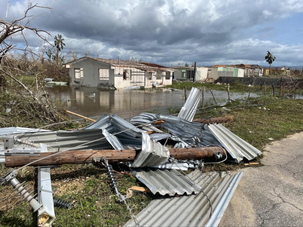
Destruction near Black River, St. Elizabeth, Jamaica. (Photo: Pan American Health Organization (PAHO), Flickr, CC BY-NC-ND 4.0)
DOERING: Haiti did not suffer a direct hit from Melissa, but its intense rains are linked to dozens of deaths or missing persons there.
CURWOOD: And we have yet to get clarity about conditions in Cuba, where Melissa was still a major category three storm when it hit a city of a half million people.
DOERING: To learn more about the extreme nature of Hurricane Melissa we called up Ryan Truchelut, chief meteorologist with the consulting firm WeatherTiger. He’s based in Tallahassee, Florida. Ryan, welcome back to Living on Earth!
TRUCHELUT: Well, thank you for the opportunity to talk.
DOERING: So what was your reaction to this incredibly strong storm?
TRUCHELUT: It was a gob-smacking, head-spinning, kind of a day to be a meteorologist. The number of records that Melissa set, unfortunately at landfall, is extensive. It's going to take time to fully gather and process the data to truly understand Melissa's strength and intensity as it was making landfall. But, I mean, suffice to say, this was one of the very strongest storms anywhere in the Atlantic ever, and it was probably the very strongest to ever make landfall on any land mass bordering the Caribbean, the Gulf or the Atlantic in recorded hurricane history?
DOERING: Wow. What are some of the factors that helped fuel the strength of hurricane Melissa?
Hurricane Melissa is among the strongest storms ever recorded in the Atlantic. Nearly 77% of Jamaica lost electricity, and Cuba and Haiti also suffered significant impacts, with flooding in Haiti resulting in an estimated 25 deaths. The U.N. called Melissa a “tremendous, unprecedented devastation.” (Photo: Pan American Health Organization (PAHO), Flickr, CC BY-NC-ND 4.0)
TRUCHELUT: Well, 2025 we've seen sea surface temperatures across the Atlantic basin be warmer than average, not quite reaching the record levels that we set in 2023 and 2024 but quite clearly, the third warmest temperatures on average across the Caribbean, going back to at least the 1970s and probably much longer than that as well. So not only were the surface waters of the western and central Caribbean 30 to 31 degrees Celsius, but those warm waters were extraordinarily deep as well. Waters above 30 degrees Celsius likely extended 65, 70, 75 meters below the surface. And that really mattered in this situation because Melissa was a slow mover. And usually when a hurricane stalls out over warm waters, it expends those waters. It basically evaporates the surface layers of the hot water. Water start to be transported kind of radially out away from the storm, and you start to upwell colder water with depth. Unfortunately, in this case, when Melissa started upwelling waters from beneath the surface, those waters were just as warm as the waters at the surface. So that is very unusual. Warm waters, or deep warm waters, cannot create a storm from nothing. You have to have a spark. You have to have an initial disturbance. You have to have favorable atmospheric conditions. You know, Melissa struggled for a few days last week after it formed, it didn't really intensify for three or four days because the atmospheric conditions were not in place. But as soon as everything lined up in the atmosphere, its intensification was explosive and sustained all the way from Friday through landfall on Tuesday, unfortunately.
DOERING: So if I understand you correctly, the hurricane is feeding off of this warm water at the surface, but then oftentimes we'll see these hurricanes actually dredge up cold water from below that, that actually slows them down. But that didn't happen in this case.
TRUCHELUT: Right. It certainly moved slow enough that if there was colder water beneath the surface, it would have probably been a factor and resulted in the hurricane's intensity leveling out at some point, in a way that just did not happen here.
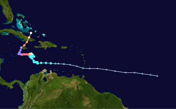
Hurricane Melissa made landfall on the island of Jamaica and continued on its path toward the Bahamas, also causing substantial damage in Cuba, and Haiti. Satellite imagery shows the storm’s path and category, with purple indicating a category 5 — the highest speed a hurricane can reach. (Color key: Teal: Tropical storm, Light Yellow: Category, Yellow: Category 2 Orange: Category 3, Pink: Category 4, Purple: Category 5) (Photo: HurricaneZeta, Wikimedia Commons, Public Domain)
DOERING: So Ryan, what do we know about how the climate crisis contributed to this particular storm?
TRUCHELUT: Well, I think that it's fair to say that while there is a history of very intense storms forming in the western half of the Caribbean in the latter third of hurricane season, October and November, I do think in this case, it's really not possible for the waters of the Caribbean to be as warm as they were and as deep as they were, minus climate change. Again, warm waters can't create a hurricane from nothing. The waters have been warm, and they've been sitting there all year, and this is the first hurricane to develop and move over the Caribbean. But it's a loaded gun, and it loads the gun even more powerfully to have that potential energy waiting for the right spark. So maybe in a non-anthropogenic climate change kind of world, perhaps you still get a Melissa. Does it claw its way down to 892 millibars and 185 or higher miles per hour, sustained winds? Maybe not quite that intense. But certainly the region does have a history of devastating storms, and as in a lot of cases, climate change is kind of acting on the margins here to make bad events a little worse, or sometimes a lot worse.
DOERING: Absolutely. So you know, as ocean temperatures continue to rise, what do you think the Caribbean region can expect in terms of future hurricanes?
TRUCHELUT: Well, basically, if you look at the 2025 hurricane season, I think what we saw this year may actually be a pretty decent guide to the kind of changes in how hurricane activity may shift over the next few decades. You know this hurricane season was forecast to be around average to somewhat above normal, but not hyperactive, not tremendously above normal. And now with Melissa happening, that's basically what we've seen. We've seen around 130 units of what's called Accumulated cyclone energy. If you go back over the last 75 years, the average is about 105, to 110. If you look back over the past 30 years, we've averaged about 125, 130 ACE units. So it's either above normal based on long term history, or right around average for what we've seen over the past few decades. But we've only seen 13 named storms, which is actually somewhat fewer than we've seen on average over the past 30 years. The truly extraordinary thing about the 2025 hurricane season is that of those 13 named storms, three of them were Category 5 hurricanes, and that's the second most that we have ever recorded in the Atlantic basin, second only to the 2005 hurricane season, where we had 28 named storms, and four of them were Category 5s. So we were extraordinarily efficient, for lack of a better word, in converting weak tropical storms into Category 5 monster hurricanes.

Dr. Ryan Truchelut is a leading professional in both forecasting and meteorological research, specializing in tropical cyclone risk and quantifying extreme event risk. He holds doctoral and master’s degrees in meteorology from Florida State University and serves as the chief meteorologist for WeatherTiger. (Photo: Ryan Truchelut)
DOERING: Yeah. I mean, we may not be getting more hurricanes, but it sounds like the ones that we do get may be bigger and badder and stronger and have more of an impact.
TRUCHELUT: There's certainly research that would suggest that. And now, with the 2025 hurricane season going under our belts, I say there's a fair amount of observations to suggest that as well. That's what I'm talking about here, that it's really these mega events, like Melissa, that are really the most impactful, both in economic and certainly in human terms. So, you know, it's very dangerous and frightening to be thinking about, you know, what if 20% of the of the storms every hurricane season turn into Category 4 or 5 storms? These kind of extreme events are well within the realm of possibility, and we need to build a society that's as resilient as possible to those risks.
DOERING: Ryan Truchelut is chief meteorologist with the weather consulting firm Weather Tiger. Thank you so much for joining us, Ryan.
TRUCHELUT: All right. Thank you.
Links
Learn more about Dr. Ryan Truchelut and WeatherTiger.
Follow Hurricane Melissa’s path.
Drone footage and raw videos of the aftermath of Hurricane Melissa.
El Pais Hurricane Melissa batters Cuba: ‘The night lasted too long’
Living on Earth wants to hear from you!
Living on Earth
62 Calef Highway, Suite 212
Lee, NH 03861
Telephone: 617-287-4121
E-mail: comments@loe.org
Newsletter [Click here]
Donate to Living on Earth!
Living on Earth is an independent media program and relies entirely on contributions from listeners and institutions supporting public service. Please donate now to preserve an independent environmental voice.
NewsletterLiving on Earth offers a weekly delivery of the show's rundown to your mailbox. Sign up for our newsletter today!
![]() Sailors For The Sea: Be the change you want to sea.
Sailors For The Sea: Be the change you want to sea.
 The Grantham Foundation for the Protection of the Environment: Committed to protecting and improving the health of the global environment.
 Contribute to Living on Earth and receive, as our gift to you, an archival print of one of Mark Seth Lender's extraordinary wildlife photographs. Follow the link to see Mark's current collection of photographs.
 Buy a signed copy of Mark Seth Lender's book Smeagull the Seagull & support Living on Earth
© Copyright World Media Foundation. All Rights Reserved
Home | Contact | RSS | Donate | Newsletter